Forest Stands Map and Survey Information
(Top of map is west. Stand I is east of South Century - off the bottom of the map)
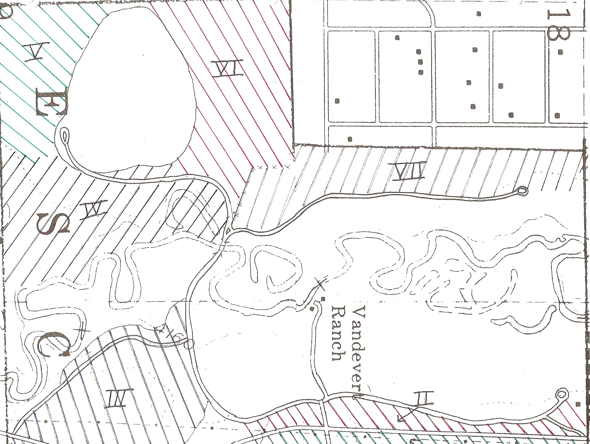
Summary by Stand
|
Stand |
I |
II |
III |
IV |
V |
VI |
VII |
Riparian |
|
Location |
East of So. Century |
Between So. Century & Schoolhouse |
Between So. Century & So. Access Road |
Between Barn and River |
Ranch Southwest Corner |
North of Large Pasture by Barn |
West of Hashknife Road |
River Corridor |
|
Acreage |
7.5 |
11 |
32 |
39 |
18 |
36 |
32.5 |
110 |
|
Forest Type |
Even-aged, single story |
Even-aged, single story |
Mixed age, two story |
Multi-aged, two story |
Multi-aged, two story |
Multi-aged, two-story |
Uneven age, two story |
Shrub, brush |
|
Species |
Lodgepole, scattered ponderosa |
Lodgepole, scattered ponderosa |
Lodgepole, ponderosa, few juniper |
Lodgepole, scattered ponderosa |
Lodgepole, scattered ponderosa |
Lodgepole, scattered ponderosa |
Lodgepole, scattered ponderosa |
Willows, scattered lodgepole |
|
Tree Density per Acre |
700 � 900 |
200-300 |
90-130 |
300-500 |
500-700 |
500-700 |
400-500 |
Willow clumps |
|
Age |
50-60 years |
50-60 years |
60-80 |
Overstory 50-60, Under 5-10 |
Overstory 60-80, Under 5-20 |
Overstory 60-80, Under 5-20 |
Overstory 60-80, Under 5-20 |
Lodgepoles 30-40 |
|
Exposure |
Southwest |
West � Southwest |
South - Southwest |
Southeast - South |
South - Southwest |
South - Southwest |
Southeast - South |
South - Southwest |
|
History |
Natural |
Thinned 1998 |
Thinned 1998, 2003 |
Grown from old meadow |
Thick, dead fuels |
Thick, dead fuels |
Pre-commercial |
Recent planting |
|
Future Manage-ment |
Pre-commercial thinning. Brush removal |
Remove bitterbrush & selected trees |
Light commercial thinning |
Convert areas to ponderosa. Pre-commercial thinning. |
Intensive pre-commercial thinning & fuels reduction |
Intensive pre-commercial thinning & fuels reduction |
More pre-commercial thinning, fuels reduction |
Nurture recent planting. Focus on wildlife. |
Following are detailed descriptions of the forest stands from the 1998 cruise:
Stand number: I
Stand acreage: 7.5 Forest type: Mixed, even-aged, single story coniferTree species mix: Lodgepole pine with
scattering of large ponderosa pine
Tree density: 700-900 trees per acre
Site index: 90
Site class: III
Age: 50-60 years
Size class: 5 inch average DBH
Elevation: 4160
Slope: 0-3
Aspect: SW exposure
Forest inventory data
(from plots sampled during cruise):
| Plot | Date | Size (Acres) | Avg. DBH* | # Trees | Trees/Acre |
| 1 | 1997 | 1/4 | 5 | 196 | 784 |
| 2 | 1997 | 1/4 | 4 | 241 | 964 |
| 3 | 1997 | 1/4 | 4 | 244 | 976 |
Understory vegetation: Scattered bitterbrush,
rabbit brush, and currant with a light component of
grasses and forbs.
Stand history: This is a naturally regenerated
thick stand of lodgepole with a few scattered large ponderosa
that has had little management. The portion south of Vandevert Road
was pre-commercially thinned in 2004 and will be thinned again in
2008.
Management opportunities: In need of
pre-commercial thinning and brush removal to allow the
residual trees to thrive. Remove diseased and suppressed trees and
most of the bitterbrush to create a fuels break in conjunction with
South Century Drive to protect the eastern boundary of the Ranch.
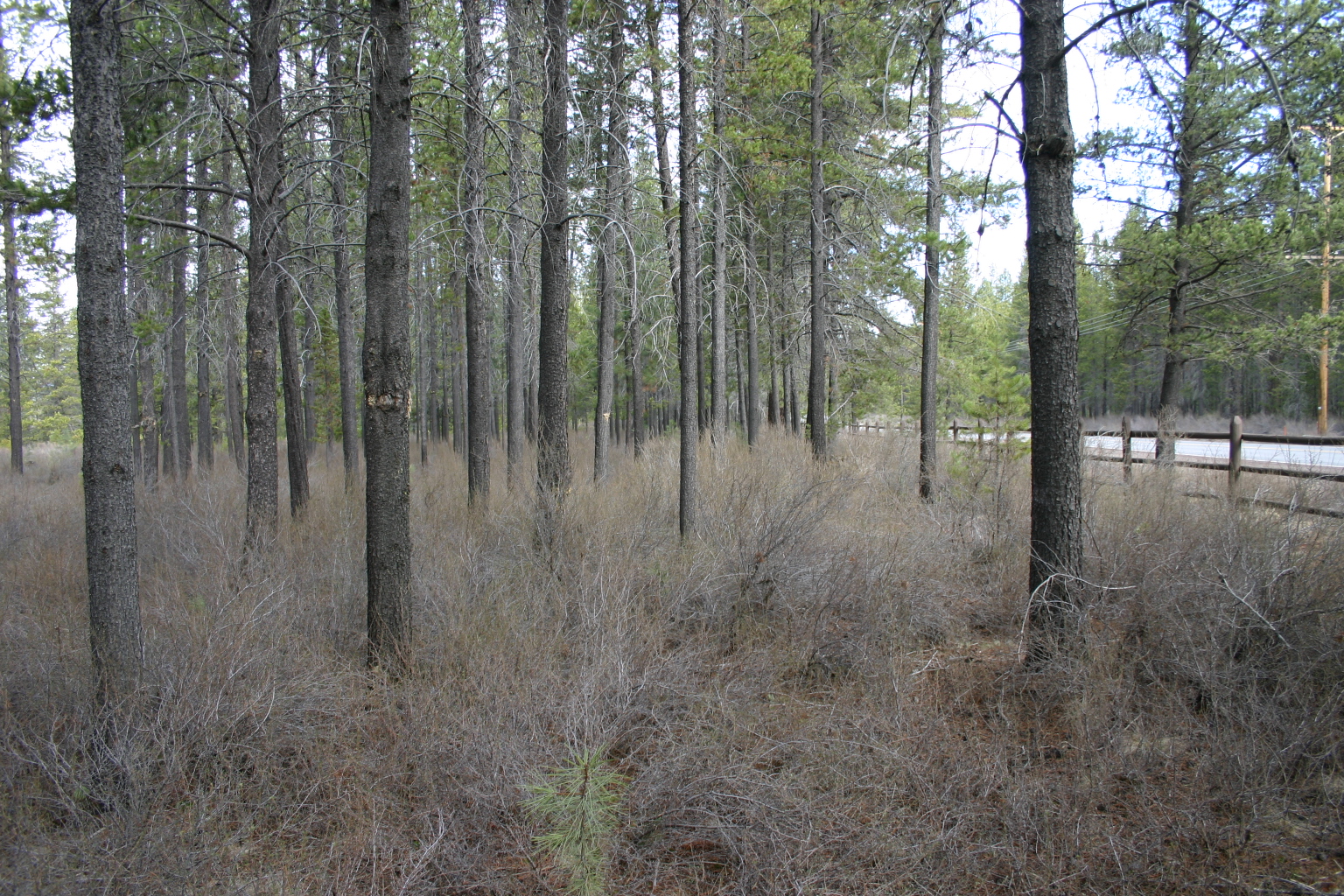 Stand number: II
(See photo to right of Stand II north of main gate)
Stand number: II
(See photo to right of Stand II north of main gate)
Stand acreage: 11
Forest type: Mixed, even-aged , single story
conifer.
Tree species mix: Lodgepole pine and ponderosa
pine
Tree density: 200-300 trees per acre
Site index: 90
Site class: III
Size class: Lodgepole 8 inch average DBH
Ponderosa 12 inch average DBH
Age: 50-60 years
Elevation: 4160
Slope: 0-3
Aspect: W-SW exposure
Forest inventory data:
| Plot | Date | Size (Acres) | Avg. DBH | # Trees | Trees/Acre |
| 1 | 1997 | 1/4 | 7 | 79 | 316 |
| 2 | 1997 | 1/4 | 11 | 55 | 220 |
Understory vegetation: Scattered bitterbrush,
rabbit brush and currant with light component of grasses
and forbs.
Stand history: This is a naturally regenerated
stand of lodgepole and ponderosa. The portion adjacent to the
schoolhouse has a very nice stand of predominantly ponderosa with
mature scattered lodgepole. This stand was pre-commercially thinned
in 1998 and some fuel ladder reduction was also done.
Management opportunities: Remove some
bitterbrush and a few lodgepole and a small number of
suppressed ponderosa to help protect stand from fire and insects.
Stand number: III
Stand acreage: 32
Forest type: Mixed, multi-aged, two story
conifer
Tree species mix: Mature lodgepole and
ponderosa overstory with naturally regenerated understory of mixed lodgepole and ponderosa. A few
small scattered juniper.
Tree density: 90-130 trees per acre
(in 1998 - is much greater in 2008 because many trees have grown
from under 6" DBH to be 6" DBH or greater.
Site index: 100
Site class: III
Size class: Lodgepole 10.5 average DBH
Ponderosa 12 average DBH
Age: 60-80
Elevation: 4160
Slope: 0-3
Aspect: S-SW exposure
Forest inventory data:
| Plot | Date | Size (Acres) | Avg. DBH | # Trees | Trees/Acre |
| 1 | 1997 | 3.3 | 10 | 316 | 95 |
| 2 | 1997 | 2.9 | 10.5 | 222 | 76 |
| 3 | 1997 | 9 | 10.7 | 1179 | 130 |
| 4 | 1997 | 4 | 10.7 | 295 | 73 |
Understory vegetation: Scattered bitterbrush
and currant with good component of grasses.
Stand history: Some commercial removal.
Salvage removal of windthrow and insect infested mature lodgepole.
Pre-commercial thinning done in 1998 and 2003.
Management opportunities: Excellent
opportunity to do light commercial thinning to widen
spacing for forest health and fire prevention. Remove some
scattered bitterbrush to prevent crown fire potential. Continue
pre-commercial thinning to further create a more desirable
ponderosa forest. Opportunity for rotational grazing to reduce
fuels.
Stand number: IV
Stand acreage: 39
Forest type: Multi-aged, two-story conifer
Tree species mix: Predominately lodgepole with
very few scattered ponderosa
Tree density: 300-500
Site index: 90
Site class: III
Size class: overstory pole size
understory sapling size
Age: overstory 50-60
understory 5-10
Elevation: 4160
Slope: 0-3
Aspect: SE-S exposure
Forest inventory data: no measurements
Understory vegetation: scattered bitterbrush
and currant
Stand history: naturally regenerated lodgepole
that has taken over old meadows. Some old oxbows and wet
areas. Open areas were planted with ponderosa pine containerized
stock in 2004.
Management opportunities: Conversion of some
areas to ponderosa pine. Pre-commercial thinning for forest health
and fire prevention. Rotational grazing for fuels reduction.
Stand Number: V
Stand acreage: 18
Forest type: Multi-aged, two-story conifer
Tree species mix: lodgepole with few scattered
ponderosa
Tree density: 500-700
Site index: 90
Site class: III
Size class: overstory 7-9
understory sapling
Age: overstory 60-80
understory 5-20
Elevation: 4160
Slope: 0-3
Aspect: S-SW exposure
Forest inventory data: no collected data
Understory vegetation: scattered bitterbrush
and currant with some grass components.
Stand history: This stand was hit by a beetle
epidemic in the early 80’s. Salvage logging was done but no
slash was disposed of. Stand is very thick with natural lodgepole
regeneration and deep with dead fuels.
Management opportunities: Stand needs
intensive pre-commercial thinning and fuels reduction work.
Fire roads and access are in. Numerous old skid trails are
prevalent. Pre-commercial thinning has been started on the western
property boundary. Reduce stems per acre, reduce disease, reduce
fuels, and reduce fire hazard potential.
Stand number: VI
Stand acreage: 36
Forest type: multi-aged, two-story conifer
Tree species mix: lodgepole with few scattered
ponderosa
Tree density: 500-700
Site index: 90
Site class: III
Size class: overstory 7-9
understory sapling
Age: overstory 60-80
understory 5-20
Elevation: 4160
Slope: 0-3
Aspect: S-SW exposure
Forest inventory data: no data collected
Understory vegetation: Scattered bitterbrush
and currant with somes grass components.
Stand history: Same as stand number V
Management opportunities: Same as stand number
V. Replant open areas to ponderosa pine. Fuels reduction
on west and north boundaries adjacent to Oregon Water Wonderland.
Stand number: VII
Stand acreage: 32.5
Forest type: uneven-aged, two-story
conifer
Tree species mix: lodgepole with few scattered
ponderosa
Tree density: 400-500
Site index: 90
Site class: III
Size class: overstory 7-9
understory sapling
Age: overstory 60-80
understory 5-20
Elevation: 4160
Slope: 0-3
Aspect: SE-S exposure
Forest inventory data:
| Plot | Date | Size (Acres) | Avg. DBH | # Trees | Trees/Acre |
| 1 | 1997 | 1/4 | 5 | 125 | 500 |
Understory vegetation: heavy bitterbrush and
scattered currant
Stand history: light commercial high-grade
entry in the 80’s. Salvage of windthrow and insect infested
1998-2003. First stage of precommercial thinning and fuels
reduction done in 2002-03. Fire access road is in. Heavy rodent
damage from porcupines and grey squirrels.
Management opportunities: Need for more
pre-commercial thinning and fuels reduction along western
property line adjacent to Oregon Water Wonderland. Replant open
areas to ponderosa seedlings in effort to convert to more desirable
species. Remove bitterbrush for fire control. Light commercial
thinning for spacing of overstory to reduce insect entry and overall
forest health.
Stand number: Riparian Corridor
Stand acreage: 110
Forest type: Shrub, brush
Tree species mix: Willow, shrubs, lodgepole
Tree density: Heavy concentrations of willow
clumps, scattered clumps of lodgepole
Site index: 80
Site class: III
Age: Willows, mature. Lodgepole 30-40
Elevation; 4140
Slope: 0-3
Aspect: S-SW exposure
Forest inventory data: No collected data.
Understory vegetation: Bitterbrush, currant,
rabbit brush, spirea, woods rose, sedges, rushes,
grasses.
Stand history: Mature willow clumps, single
and small clumps of lodgepole invasions from lack of
grazing, oxbow areas with sedges and rushes, heavy grass cover, very
little management until recently.
Management opportunities: Almost unlimited
potential for wildlife enhancement, especially for riparian
and water dwelling birds and mammals. The entire riparian corridor
was planted with ponderosa pine, cottonwood, mountain alder, red
osier dogwood and willow in 2004 under a cost share agreement as
part of our CCRP contract. Except for the ponderosa and willow,
almost none of the plants have survived. CCRP advises they did not
test the soil for suitability and it turns out to have been
inappropriate. In spite of screens to protect the plants, predation
by gophers and other animals was substantial.
Return to Stewardship Plan Table of Contents
Copyright 2004-2010 The Vandevert Ranch Association. Neither the Association nor its members guarantees the accuracy or completeness of information or representations on this Web Site. Buyers should obtain definitive information from their real estate agent.