Stream Flows
Seasonal stream flows in the Little Deschutes
are substantially different from what would naturally occur. The
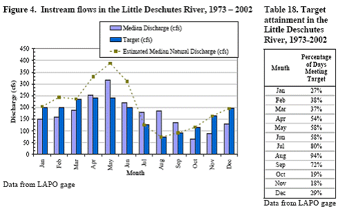
chart below shows the estimated median natural stream flow by month
as a green dashed line. Actual stream flows (median discharge in
cubic feet per second) are shown in light blue. Actual flows are
lower than natural in October through June and higher than natural
in the summer months of July through September.
(Figure 4 and Table 18 are from the August
2006 final report of the Deschutes Water Alliance on Instream Flow
in the Deschutes Basin, prepared by the Deschutes River Conservancy
under a grant from the Bureau of Reclamation. The report is
available at
http://www.deschutesriver.org/Water_Summit/Summit_InstreamFlow/default.aspx
)
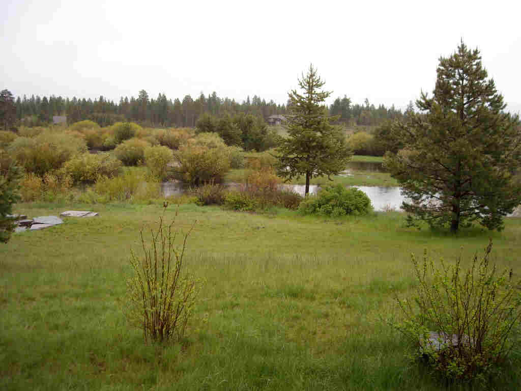
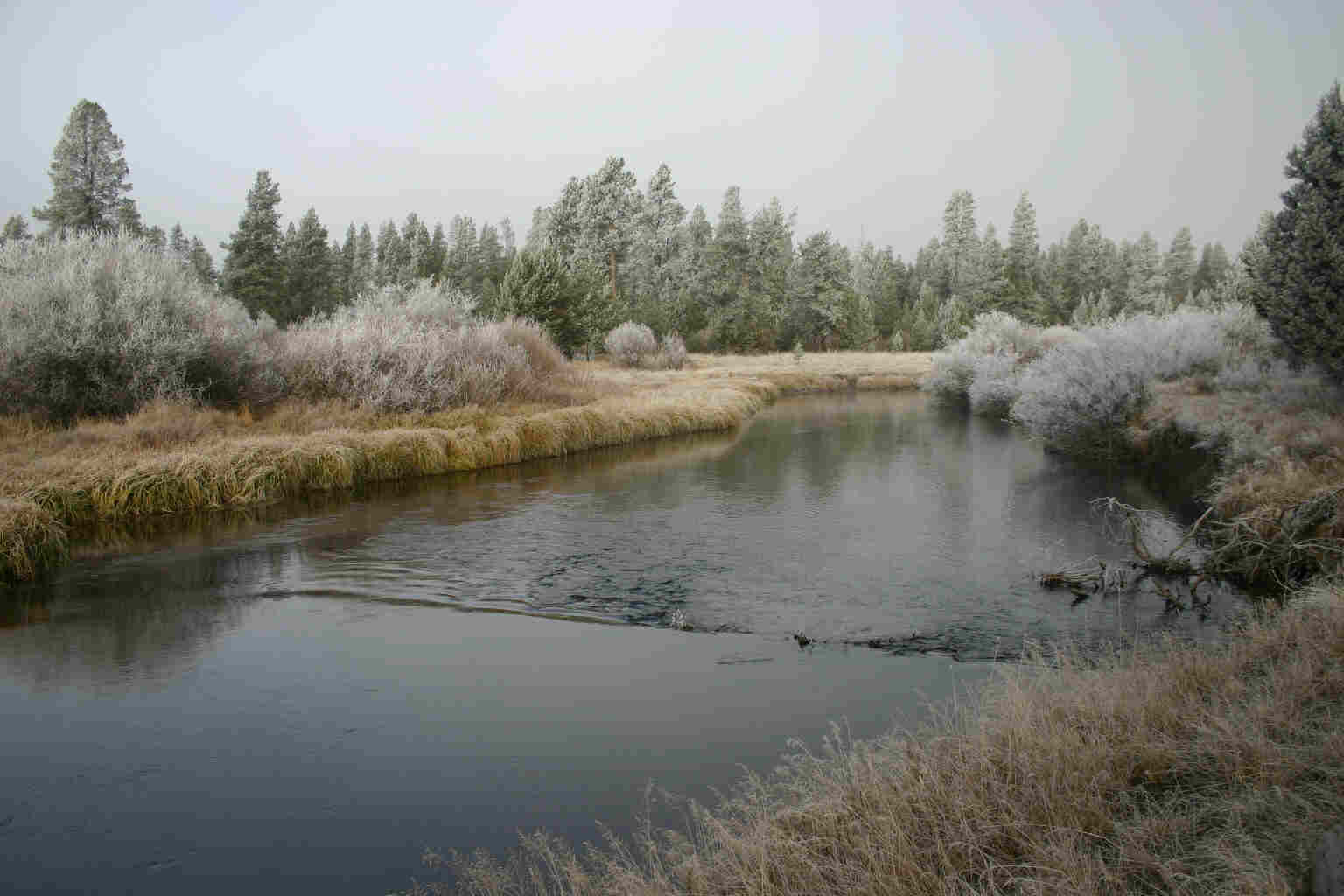 The
photo on the left shows the river at high water in May 2008 (with
flooding on the wetlands beyond the river). The photo on the
right shows the river at low water in November.
The
photo on the left shows the river at high water in May 2008 (with
flooding on the wetlands beyond the river). The photo on the
right shows the river at low water in November.
Actual stream flows differ from natural flows
because water is stored in Crescent Lake in the fall, winter, and
spring. Crescent Creek, which empties from Crescent Lake, is the
largest tributary of the Little Deschutes. Even after Crescent
Lake Dam was first built in 1922, there may have been less water
stored behind it in the 1920's and 30's than now and stream flows
may have been closer to natural. Grace Vandevert reports, "We
had to tie a boat to the back porch when the water got very high a
couple of times. Almost the whole meadow below the house (just to
the northwest in that first bend of the river) would be flooded. Dad
had to still milk the cows that were across the footbridge in the
corral - - and he couldn't wade in the water. I doubt the
footbridge was even very safe with all that water. It didn't
last too long - -maybe two or three days and then receded."
The Deschutes River Conservancy has established
target monthly flows that it believes will be most beneficial for
the Little Deschutes and for the Deschutes River into which it
drains. The target flows (shown in dark blue in the chart
above) are all
equal to or less than the estimated natural flows. The targets
assume that some water will be stored and then released later on but
the flow will be more even over the year. Actual flows are
significantly different from the targets (i.e. higher in April
through September and lower in October through March).
Stream Flow Impact on Fish Habitat
The Deschutes Subbasin Plan reports that a loss
of riparian habitat and a reduction in the complexity of the
instream habitat are factors that limit fish production in the
Little Deschutes subbasin. The plan suggests that flow alterations
have contributed to these problems. It appears to the authors of
the Vandevert Stewardship Plan that the lack of naturally high
spring floods to dig the channel deeper has made the river wider and
shallower – and therefore more susceptible to heating up from the
rays of the sun. The lack of spring floods has also left sediment
between river bottom rocks, making the river less suitable for
spawning. See “Trout Habitat”, the next page after
this in the
Riparian Section of the Stewardship Plan. The Deschutes Subbasin
Plan is available at
http://www.nwcouncil.org/fw/subbasinplanning/
Flow Impact on Temperature
As evaluated by the Deschutes Water Alliance,
the most important problem is not that the seasonal flows are too
great or too little, but that the storage of water in Crescent Lake
during the fall and winter allows the water to warm up before it is
released into the river in the spring and summer. The water is
stored and released to supply the Tumalo Irrigation District which
owns the rights to the water.
Opinions on the ideal water temperature for
trout range from 57 degrees to 62 degrees Fahrenheit, although trout
can adapt to a wide range of temperatures if the temperature does
not change too rapidly. Over 70 degrees trout are stressed and at 80
degrees they are likely to die if they cannot find cooler water deep
in the river. At the LAPO gauge upstream near La Pine, the water
temperature reached 80 degrees only once in the last five years, on
July 24, 2006. This would suggest that, while the water temperature
is not ideal for trout, it is not an insurmountable barrier to their
surviving in the river. Maximum water temperatures by year were as
follows:
Little Deschutes Maximum Water Temperature by
Year – LAPO Gauge
|
Year |
Maximum
in Year |
|
2003 |
70.4 |
|
2004 |
69.5 |
|
2005 |
77.8 |
|
2006 |
80.28 |
|
2007 |
77.73 |
For historical measurements of stream flow and
water temperature at the LAPO gauge, see
www.usbr.gov/pn-bin/arcread.pl?station=LAPO
Dissolved Oxygen
Oxygen dissolved in the water is essential for
the survival of fish, all other water animals, and zooplankton.
Oxygen also improves the odor, clarity, and taste of water. The
Little Deschutes is listed by the EPA from its mouth up to well
above the ranch for low levels of dissolved oxygen year round.
Water storage in Crescent Lake from late September until April or
May is a major factor in increasing the water temperature (for which
the river is federally listed for 50 to 73 miles above the ranch).
Higher water temperatures are a factor in causing low dissolved
oxygen levels.
Restoring Stream Flows
Partnering with federal, state, and regional
agencies – and with many non-governmental organizations - the
Deschutes River Conservancy (DRC) is leading efforts to restore
stream flows and improve water quality in the Deschutes Basin.
Principal programs are water conservation (e.g. reducing leaks in
irrigation canals), water purchase, water leasing, and habitat
enhancement. Through the Deschutes Water Alliance Bank, the DRC
enables farmers to keep the right to maintain their water rights
while leaving the water in the river or leasing it to other water
users. This means that less water needs to be stored for irrigation,
average and maximum water temperatures decrease, and stream flows
can more closely approximate ideal and natural patterns. The DRC
programs are working well but have barely begun to impact the
overall river system.
In 2008 the Tumalo Irrigation District, which owns the rights to much of the water flowing out of Crescent Lake, agreed with the state to forego 8 cfs (cubic feet per second) of this water during the irrigation season (April 1 through October 31). This means the Oregon Water Resources Department (OWRD), which actually controls the release of water from Crescent Lake Dam, will have about 145 million cubic feet of water each year to release when it sees fit during the irrigation season. Oregon Fish and Wildlife, which advises (OWRD), expects to request most of the water in July through October with possibly a little in April. The objectives of Fish and Wildlife are to provide adequate water for fish during low water periods and to even out flows as much as possible in order to stabilize streambanks and provide as stable an environment as possible for fish. The "new" water will increase average stream flows in July through October by roughly fifteen percent.
Continue to Trout Habitat
Return to
Stewardship Plan Table of Contents